


-
近炸引信是导弹在弹道末端对目标进行探测、识别、启动的功能部件,其性能是武器系统按预定策略与功能对目标实施高效打击的关键因素。激光引信因其探测场精度高、抗电磁干扰能力强、体积小等优势,成为一种主流近炸引信而广泛应用于世界各国的多型导弹[1-2]上。但随着战场环境的复杂化、目标类型的多样化,对近炸引信的抗干扰性能和精确打击的需求越来越高。特别是在现代海战中,面临的反舰导弹、巡航导弹等空袭威胁多为超低空或掠海飞行目标,空空导弹需兼顾拦截超低空掠海飞行目标的能力,才能更适应现代战争的需求[3-6]。目前世界先进水平已能在距海面3 m的高度掠海飞行,此时复杂的海面背景杂波不仅影响导弹制导系统对目标的探测、跟踪,在末端交会段,海面背景也会进入引信的作用区域内,严重影响引信工作,导致虚警或启动能力下降。因此,提高引信抗超低空海背景干扰能力一直是拓展其战场适应性的研究热点。
由于海平面的散射特性在激光引信工作波段呈现镜面反射的特征,其对海杂波抑制比无线电引信更具体制优势。目前激光引信采用多象限分区波门压缩、双波束探测等技术来实现海波的抑制[7-8],其中:波门压缩技术是通过实时检测杂波信号,通过移动与压缩距离波门的方式实现对海面背景杂波的抑制。但该方式同时会抑制引信一部分的探测能力,减少引信对目标的启动区,导致导弹杀伤能力的下降。双波束探测技术是利用海面的镜面反射特性,通过检测前、后探测波束的回波信号时间差来区分目标与海面的杂波干扰,但该方式易受海情变化和导弹交会姿态的影响。激光成像探测是一种可以精确、快速获取目标三维空间信息的主动探测技术,该技术能够识别目标及其关键部位,可实现精确引战和高效毁伤效果。目前激光成像技术主要对引信抗云烟雾干扰、精确引战方面进行研究,对抗低空海背景干扰技术的相关研究较少[9-14]。文中提出了一种数字化激光成像低空海背景的目标识别方法。该方法基于海平面的镜面反射效应,利用探测系统对周向不同方位角的光学截止,接收到的海面杂波在空间分布呈现离散性,该特征与目标的几何形体的连续特征存在差异。
在成像探测系统实现方式方面,目前引信的周视成像探测方案主要包括窄波束电机高速驱动周视机械扫描探测、线阵APD推扫成像两种主流方式[10]。文中基于激光引信的海面激光散射特性,提出了一种数字化激光扫描的精细化探测方法。该方法是利用窄视场激光通过周向分时高速固态扫描的方式获取周向目标的反射回波,其数字化是利用共用接收系统后配置高速ADC采集电路,可以将分时工作的激光回波幅度、时延等时域信息数字化,利用不同方位的激光回波点的能量和距离分布特征串行计算实现目标的识别。文中通过海面及激光探测数字建模,仿真分析了海杂波的光学反射特性受激光视场角和入射角的影响,并基于弹目高速交会工作的特点,设计了帧内判定,帧间累积的低空海背景目标识别方法。该方法通过直通滤波、数学形态学滤波、目标形态特征等方法能快速滤除海背景离群点,并进行仿真和试验验证。文中的相关技术可为激光引信抗低空海面环境干扰技术提供方法和思路。
-
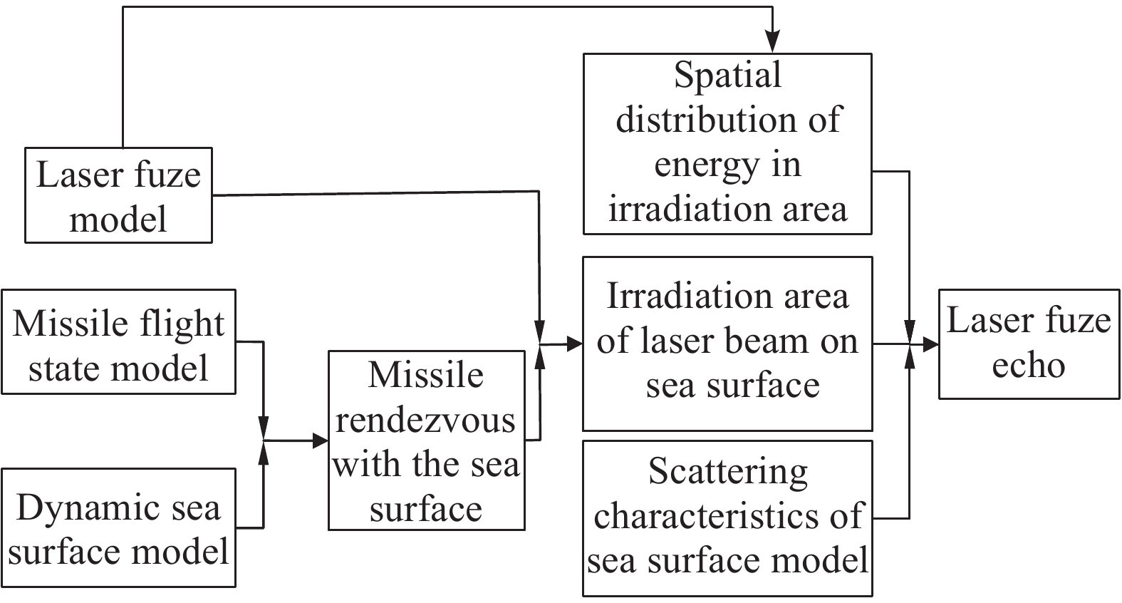
激光海平面散射特性研究是激光引信抗海面背景干扰技术的理论基础,该散射特性通常基于模型仿真分析的方法,主要包括动态海面几何建模、海面激光散射特性建模、激光引信建模等模块,通过仿真实时获取激光海面回波信号。其仿真流程图如图1所示。根据导弹飞行状态和动态海面的几何模型,可以获得导弹与海面的交会状态,在该状态下结合激光引信模型的激光波束的空间分布,获得激光波束对海面的照射区域。在照射区域,利用海面面元的散射特性模型计算动态海面的引信回波。

图 1 动态海面激光回波仿真流程
Figure 1. Simulation process of dynamic sea surface laser echo
-
动态海面建模一般采用线性滤波法或者线性叠加法,两种方法建模时都是基于海谱的。在自然条件下,海面可以认为是由无数多个振幅、方向、频率各不相同以及相位杂乱的谐波随机构成[15-17]。这些谐波的频域分布简称海谱。当采用基于海浪谱与方向谱函数的建模方法时,海面的波面方程为[18]:
$$ Z\left(x,y,t\right)=\sum _{i=1}^{m}\sum _{j=1}^{n}{A}_{ij}{\rm cos}\left({k}_{i}\mathit{x{\rm cos}}{\theta }_{j}+{k}_{i}\mathit{y{\rm sin}}{\theta }_{j}-{\omega }_{i}t+{\varepsilon }_{ij}\right) $$ (1) 式中:m为频率分割数;n为方向分割数; Aij为第i个频率、第j个方向成分波的波幅;ki为波数;εij为第i个频率、第j个方向波的相位,其值为0~2π间的随机值。
波幅Aij与海谱
$ \mathrm{S}\left({\omega }_{i}\right) $ 和方向分布函数${G}\left({\omega }_{i},{\theta }_{j}\right)$ 相关,其表达式为:$$ {A}_{ij}=\sqrt{2S\left({\omega }_{i}\right)G\left({\omega }_{i},{\theta }_{j}\right)\Delta \omega \Delta \theta } $$ (2) 根据激光引信的应用特点,海浪模拟时选PM谱,该谱是Pierson与Moscowitz通过对北大西洋水文状况的数据进行统计分析得到的,他们选取一定风速范围内的数据集,按照风速大小分为5组数据进行平均化处理,发现其具有很好的相似性。该谱基于风速驱动,适于充分生长的海浪,其表达式为[17]:
$$ S\left({\omega }_{i}\right)=\frac{\alpha {g}^{2}}{{\omega }^{5}}{\rm exp}\left[-\beta {\left(\frac{g}{{U}_{\omega }}\right)}^{4}\right] $$ (3) 式中:α=8.1×10⁻³;β=0.74;g为重力加速度;U为海面风速。海浪方向分布函数依据波浪立体观测计划(SWOP)给出。在仿真中将计算不同风速和风向得出的海面高度场数据导入到OpenGL中实现可视化,图2所示为不同风速和风向参数模拟的动态海面几何模型。

图 2 (a)风速3 m/s,风向0°的动态海面几何模型;(b)风速10 m/s,风向45°的动态海面几何模型
Figure 2. (a) Dynamic sea surface geometric model with wind speed of 3 m/s and wind direction of 0°; (b) Dynamic sea surface geometric model with wind speed 10 m/s and wind direction 45°
目前使用的海面状态标度有Beaufort和Douglas两种,前者偏重于风向而不是海浪方向, 因此,用Douglas标度描述海杂波更合适。海况与风力、浪高、风速对应关系见表1。可见,海况与海面风速直接相关,风速越大,海浪的有效波高和波高极值越大。
表 1 海况与风力、浪高、风速对应关系表
Table 1. Correspondence between sea conditions and wind, wave height and wind speed
Sea state Wind Wind speed/m·s−1 Wave height/m Significant Extremum 0 Level 0 0.0-0.2 − − Level 1 0.3-1.5 0.1 0.1 1 Level 2 1.6-3.3 0.2 0.3 2 Level 3 3.4-5.4 0.6 1 3 Level 4 5.5-7.9 1 1.5 4 Level 5 8-10.7 2 2.5 5 Level 5 10.8-13.8 3 4 Level 5 13.9-17.1 4 5.5 -
激光引信工作在近红外波段,当激光束照射到海面时,每个小平面对入射激光的散射可以看作镜面反射,该过程满足菲涅耳反射定律。基于上述原理,在计算引信接收海平面背景反射时,将海面细分为由斜率满足一定分布的许多微小平波面。由于激光引信的激光发射和接收的视场间距远小于引信距离海面的距离,接收光学视场仅能响应激光发射反方向的反射回波,因此,激光光斑反射方向被海面波动调制后,其反射光进入接收视场仅为后向反射回波。根据激光探测距离方程,若距离引信
${R_{{n}}}$ 处微小平面面元Sn被激光照射且反射的回波进入引信接收视场,则其功率${P_{{{R}}_n}}$ 可近似表示为:$$ {P}_{R_n}=\frac{{P}_{T}\rho {\tau }_{R}{\tau }_{T}{\tau }_{A}{\sigma }_{n}\mathit{\rm cos}{\phi }_{n}{A}_{n}}{2\pi {R}_{n}^{2}{S}_{t}\left({R}_{n}\right)} $$ (4) 式中:
$ {P_T} $ 为激光引信的激光发射功率;$\; \rho $ 为反射面Sn的菲涅耳反射率;$ {\tau _T} $ 为引信发射光学系统的透过率;$ {\tau _R} $ 为引信接收光学系统的透过率;$ {\tau _A} $ 为2倍海面距离${R_{{n}}}$ 的大气透过率;$ {A_n} $ 为接收视场的有效口径;$ {\sigma _n} $ 为海面面元的面积;${\varphi _{{n}}}$ 为入射光与面元法线的夹角;${S_{{t}}}\left( {{R_{{n}}}} \right)$ 为引信距离海面${R_{{n}}}$ 处发射光束的截面积。$$ {S}_{t}\left({R}_{n}\right)={\theta }_{n}{\omega }_{n}{{R}_{n}}^{2} $$ (5) 式中:
$ {\omega _n} $ 为激光弧矢方向的视场角;$ {\theta _n} $ 为激光子午方向的视场角。海面回波信号的总能量
${P_{{R}}}$ 是由激光波束照射在海面上光斑覆盖的所有${R_{{n}}}$ 的回波能量之和。$$ {P}_{R}=\varSigma {P}_{{R_n}} $$ (6) 结合海面随机运动规律的研究和激光引信弧矢方向周视探测场的特点,由公式(1)~(3)可见,在相同
${R_{{n}}}$ 距离的情况下,海杂波信号能量大小的主要影响因子是${\varphi _{{n}}}$ 和${\omega _{{n}}}$ 。其中${\omega _{{n}}}$ 影响激光光斑照射海面的区域面积,${\varphi _{{n}}}$ 影响激光的反射方向。为研究入射光束与海面夹角
${\varphi _{{n}}}$ 和光束弧矢方向视场角${\omega _{{n}}}$ 对激光回波的影响,进行了不同视场角和入射角对海面的回波特征仿真。选取宽视场和窄视场两种探测视场角分别在不同海况下进行不同入射角的回波特征仿真,两种视场角的仿真场景见图3。其中,宽视场角为45°,窄视场为2°,分别对3 m/s和15 m/s两种风速下的海况进行仿真。45°视场角分别仿真了0°、15°、30°、45°入射角的情况。仿真以引信与海面在交会过程对不同入射角的回波进行采集,交会速度为500 m/s,进行200 ms的采集,得到100 m的交会距离,在该距离内不同入射角情况下的回波峰值变化曲线对比见图4。
图 3 (a) 45°视场角探测的海面回波仿真场景;(b) 2°视场角探测的海面回波仿真场景
Figure 3. (a) Sea surface echo simulation scene for 45° field of view detection;(b) Sea surface echo simulation scene for 2° field of view detection

图 4 (a) 低海况下宽视场探测回波随入射角的变化曲线;(b) 高海况下宽视场探测回波随入射角的变化曲线
Figure 4. (a) Variation curves of wide-field detection echo with incident angle in low sea state;(b) Variation curves of wide-field detection echo with incident angle in high sea state
窄视场探测的视场角为2°,分别对3、15 m/s两种风速下的海况进行仿真,由于窄视场照射在海面的光斑变小,海面对其截止的范围角度变小,因此,视场角分别选择了0°、2°、4°、6°、8°的入射角情况。仿真以引信与海面在交会过程对不同入射角的回波进行采集,其回波脉冲随采集点次数增加而呈离散分布,其对比分布见图5。
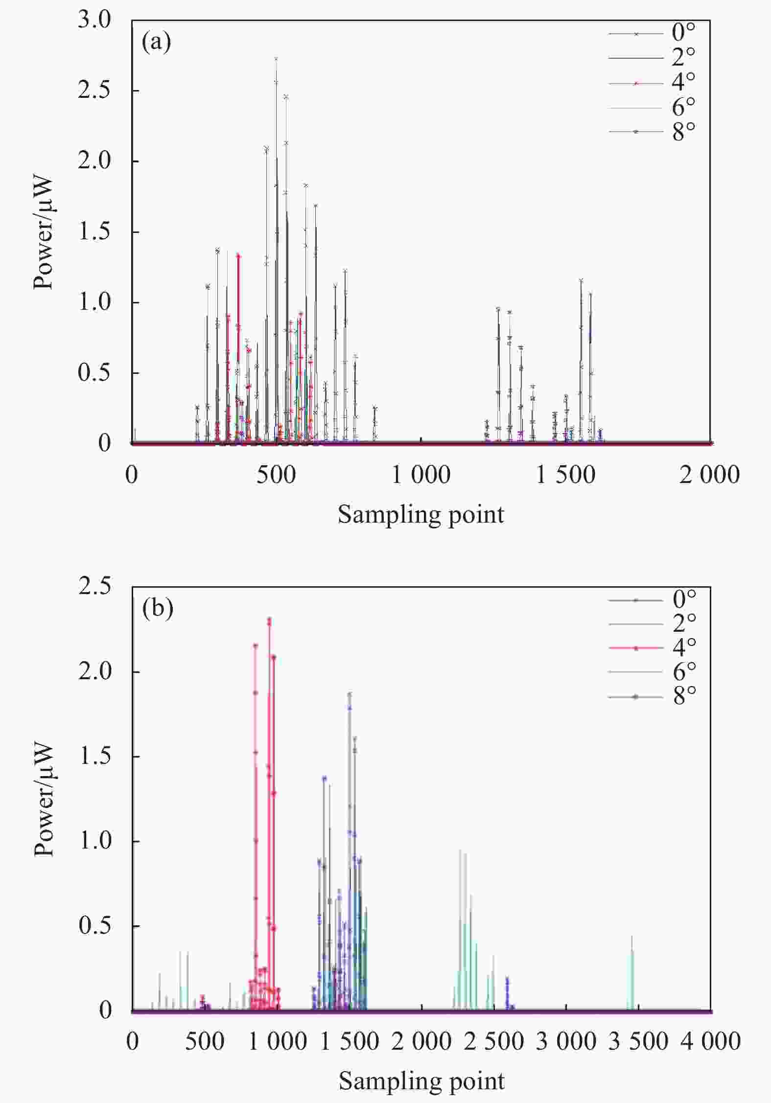
图 5 (a) 低海况下窄视场探测回波随入射角的变化曲线;(b) 高海况下窄视场探测回波随入射角的变化曲线
Figure 5. (a) Variation curves of narrow-field detection echo with incident angle in low sea state;(b) Variation curves of narrow-field detection echo with incident angle in high sea state
根据仿真结果,海杂波的特性如下:
(1) 当系统采用大视场角探测,由于大视场角激光束照射海面所覆盖的光斑尺寸较大,其海面小面元法线方向满足激光接收方向的数量远多于小视场探测,因此,通过大量小面元反射叠加后,大视场探测系统接收到的海面背景反射能量大于小视场角探测系统;
(2) 在周向方向的激光束入射角
${\phi _{{n}}}$ 从0°(垂直海面)不断增大时,由于整个海面的镜面反射效应,后向反射回波能量随入射角的增加而降低;大视场角探测系统的海背景反射回波随入射角的变化连续降低,而小视场角探测系统受海面高度起伏的后向反射方向的离散性大,随入射角变化时有时无,呈现闪烁特征;(3) 风速是影响海情的重要因素,风速越大海情等级越高,随着风速的增加,海面表面的激光条形光斑逐渐破碎成闪烁块,亮带聚集程度降低,海面波动幅度增加,发生大斜率波面的概率也增大,进入接收视场的面元面积就会扩大,会在一定程度上降低入射角
$\varphi_{{n}}$ 变化的敏感性。这对海面照射光斑大的宽视场系统有较大影响,会导致大角度入射回波功率增加,使各角度回波功率幅度更为均化;而对于窄视场的探测系统,高海清会增加海面的波动性,但对回波的离散性影响不大。 -
与海面激光反射特性不同,目标的散射过程是体目标的漫反射,在目标漫反射系数一定的情况下,其回波功率主要由目标距离和形体决定。当目标不变,俯仰角γ变化时,接收功率为朗伯体,随角度呈三角函数连续渐变的特征。图6是仿真获取的不同俯仰角交会时的目标回波变化特征。而当探测系统采用宽视场探测时,海面回波与目标回波都为连续变化特征,当目标的反射率较低时,该特征差异不易区分。因此,对于采用空间窄视场细分的成像探测系统,海面回波在连续视场为离散的闪烁特征,与目标回波为连续实体反射特征在空间分布的特征存在差异。因此,采用激光成像探测系统进行低空海面背景下的目标识别具有体制优势。

图 6 (a) 目标数字模型;(b) 不同俯仰角交会情况下目标回波的功率曲线
Figure 6. (a) Target digital model;(b) Target laser echo power curves with different pitch angles
-
激光扫描成像探测通常利用一定视场角的激光束在探测空间连续等角度偏转,分时获得不同角度偏转方位的目标反射回波特征,通过时序组合可以获得目标形体、距离等精细化的空间特征。其成像过程相当于若干个方位角不同的窄视场探测系统对目标不同部位进行探测,物像关系由不同方位角的映射关系决定,因此,成像系统获取目标或海面的单帧成像特征是由窄视场探测波束在不同入射角情况下的空间组合。海面的激光成像的各像元分布规律符合上述窄视场探测随入射角变化而呈现的离散特征,这种海面与目标在成像系统上的空间分布特征差异是解决超低空海面背景干扰和目标识别的有效手段。
根据上述目标特性分析和弹载探测系统适时性需求,设计了一种小视场阵列激光扫描成像探测系统。该激光成像探测系统由8组阵列激光扫描发射机、8组高速接收机、供电系统、信号采集控制系统组成。该成像系统的核心是阵列激光扫描发射机,该发射机由阵列激光器和发射光学系统组成。当系统工作时,阵列激光器由信号采集控制系统控制实现每个管芯的分时工作,阵列中不同管芯发光后通过发射光学系统准直和偏转后实现不同方位角的激光发射,单次发射波束的视场为2°×1°的窄视场,通过23元阵列激光器2°的等角偏转,能覆盖46°的扫描探测场。为保证单次探测光束的飞行时间,相邻管芯之间的扫描间隔为200 ns,帧内扫描频率为5 MHz,因此,8组发射机扫描360°一周的时间为36.7 μs,可以适应高速目标探测。高速接收机由接收光学系统、探测器模块组成,能实现匹配发射46°的接收视场和6 ns的窄脉冲激光的高速响应,可大幅提高激光回波在时域特征的分辨力。整个探测系统通过8组发射和接收组合形成周视360°的环形探测场。信号采集和控制系统采用高速ADC和FPGA高速信号处理器件,可实现1 Gsps的采样和波形特征处理能力。其组成原理框图见图7。

图 7 阵列激光扫描成像原理框图
Figure 7. Block diagram of array laser scanning imaging
其工作过程和原理如下:当系统供电后,信号采集控制系统的多线时钟独立控制每个阵列激光器的发光芯片分时工作,激光芯片依次输出的激光束通过光学系统按照每间隔2°进行等角偏转,通过多线的激光连续拼接覆盖周视360°的连续探测场。当探测视场内出现目标或背景干扰时,被干扰或目标反射的多个通道激光束依次被共视场的单元接收系统接收后分时输出多个通道的回波波形,多通道的回波串行输出后被后级高速ADC采样电路实时采集,可得到多个通道激光回波波形的幅度、延时等时域信息,在下一帧数据到来前串行计算每个点的幅度、距离的数字量,信号采集控制系统根据发射扫描的时间戳将接收到的信号时序融合实现单帧目标灰度/距离数字剖面,形成单帧一维灰度/距离像,并通过交会过程推扫获得多帧目标刨面,形成激光二维灰度/距离像。
该成像方式采用固态电控扫描方式,能解决传统高速电机驱动机械扫描成像方式存在的结构复杂、扫描速度低、噪声大等问题,适用于高速目标的识别与启动。相对于采用激光回波并行处理的线阵APD推扫成像方式,阵列激光扫描成像通过串行工作方式,可以低成本、低功耗地实现回波信号的数字化,实现全数字化信号处理。当系统采用8位1 Gps的ADC,可以细分256级灰度等级和1 ns的时间分辨率,便于实现精细化、数字化的特征识别。
-
根据激光引信的探测能力和海面背景反射率,抗海面背景干扰问题主要涉及弹道末端与海面交会的部分。相对于飞机类目标,导弹类目标的形体小,具备掠海飞行能力,激光引信应能抵抗严酷的超低空海背景干扰,而采用周向角空间分辨率高的激光成像引信,对抗海杂波的干扰和目标识别更加有利。
激光成像引信的角分辨率是实现目标形体精细化探测的重要因素,角分辨率越高获取目标特征的精细化程度越高,但过高的分辨率会增加硬件实现难度以及后级信号处理的复杂性,这并不符合高速交会的特定环境。因此,角度分辨率的设计,以各种交会条件下能正确识别目标为标准。由于低空海面目标最严酷的任务是对巡航导弹等小型目标的打击,根据其目标激光最小截面尺寸和探测距离,选择2°周向角分辨率可以覆盖目标最小截面的6个点,通过仿真计算该分辨率可以满足该类目标特征的识别。
图8为海面坐标系,其中海面坐标系为CS0,目标坐标系为CS1,将海面坐标系视作场景的大地坐标系,设定激光引信激光发射脉冲入射角度为
$ \left({\mathrm{\theta }}_{i}{,\mathrm{\varphi }}_{i}\right) $ 。由于窄视场激光束的回波信号受入射方向影响较大,当导弹以不同俯仰角度与海面交会时,发射光垂直海面入射时的海面回波最大。当入射角度增大时,海面后向反射回波会被周视薄扇形的接收视场光学抑制,而目标的朗伯体散射回波并不会截止,因此,以最严酷的周视光束垂直海面照射的交会条件来设计其抗海面背景干扰的方法。
图 8 海面坐标系
Figure 8. Sea surface coordinate system
当引信探测场与海面背景交会时,根据周视扫描探测的工作方式,单帧360°扫描可以获取角分辨率为2°的180个距离和回波能量的有序数据,可用的极坐标表示为:
$$ P=\left\{\left({D}_{i},{\varOmega }_{i}\right)|i=1,\cdots ,180\right\} $$ (7) $$ P=\left\{\left({A}_{i},{\varOmega }_{i}\right)|i=1,\cdots ,180\right\} $$ (8) 式中:
$ {D}_{i} $ 为扫描点i到引信的距离;$ {A}_{i} $ 为扫描点i的回波能量;$ {\varOmega }_{i} $ 为扫描点i的方位角与极轴的夹角。各扫描点数据有序组合形成距离/灰度像数据集合。扫描一帧所获的距离信息可用序列t1=[D1 D2 ··· D180]T表示,其幅度信息可用序列t2=[A1 A2 ··· A180]T表示,每探测一帧获得两组数据集合。在交会过程中,经过N次重复扫描后,形成N个序列,将N个序列组合,得到目标局部的距离像和灰度像。当目标在距离海平面一定安全高度的区域内飞行,导弹通常在目标上方或者侧方以不同方位角和距离进行交会,该应用场景的特点如下:
(1)在点云密度分布特征方面,目标漫反射为连续分布,海面的镜面反射多为离散分布;在点云能量特征方面,由于海面的菲涅耳反射系数小于目标的漫反射系数[18-19],在相同距离时,目标回波幅度通常大于海背景,但纯能量探测对低反射率目标的识别能力会下降;
(2)由于目标处于海平面一定距离以上飞行,目标与背景相对位置差异导致目标回波的点集合与海背景杂波点集合分界之间存在明显的距离差。而两者表面点云集合的距离和能量分布由目标的形体特征决定;
(3)由于扫描角分辨率一定,其回波的数据点密度随反射物距离的增大而减少,目标距离越近,数据点越密集。
根据高速交会对目标识别的实时性需求,无法直接采用传统的K-means、DBSCAN等聚类算法对目标和背景干扰进行分类。这是由于该类算法需要进行全局搜索和计算,其算法适时性不高[20-22]。为提高实时性,在交会过程中采用帧内判定、帧间累积的方式进行目标识别。即在帧内通过各点连续性、幅度大小和距离信息对目标单帧中心位置进行识别,并通过不同帧间目标中心位置的变化量来最终进行目标识别判定。
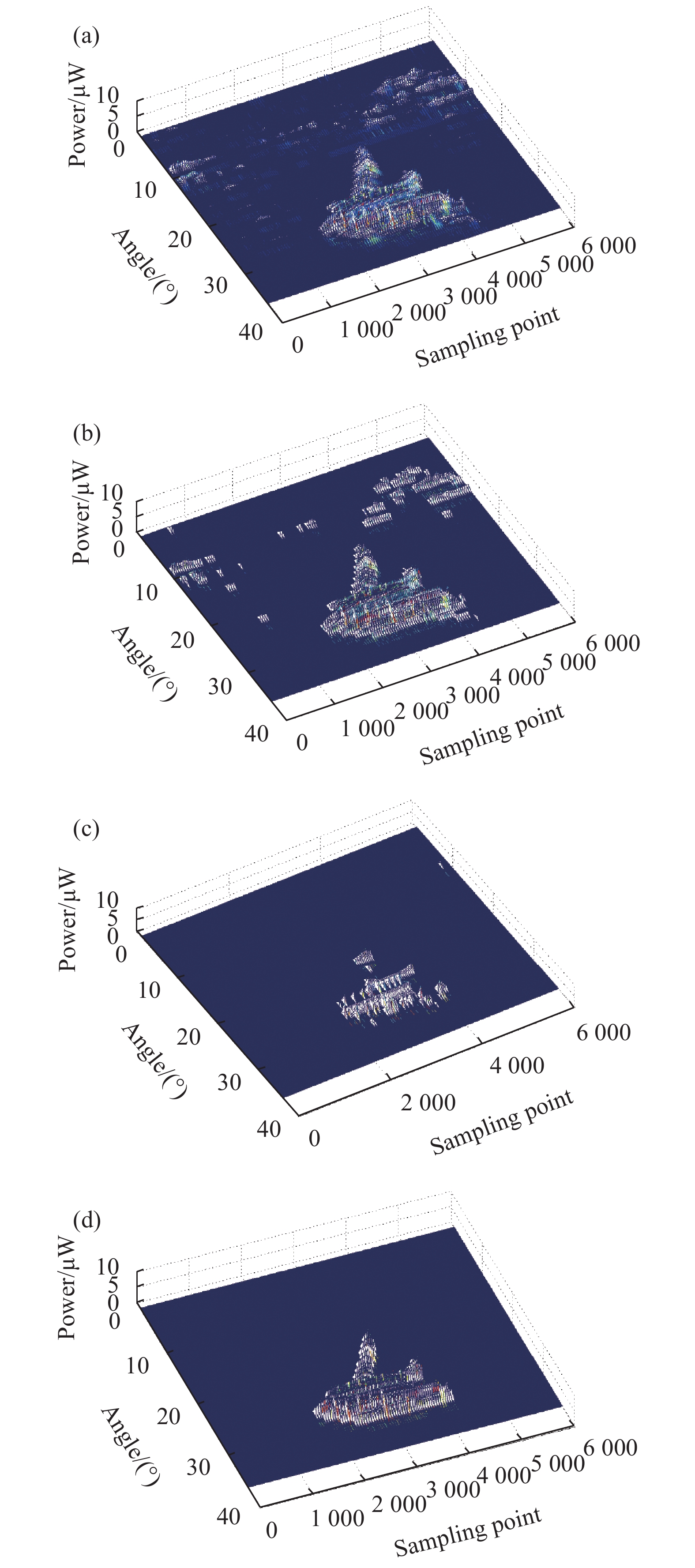
考虑到光束非垂直入射的交会条件,海面背景在一定入射角范围内具有一定强度的散射信号,为降低后续目标识别数据的复杂性,适应弹载识别算法的实时性,第一步,在帧内通过直通滤波的方式进行回波阵列数据的筛选。根据系统探测信噪比和探测距离分别设定回波的能量阈值,对回波幅度序列进行筛选,剔除出不在预期值域范围的点,并将剔除数据置零,形成滤波后的回波阵列。由于水面的近红外波段反射率通常低于目标反射率,该过程能够快速滤除非近似垂直入射情况下的背景噪声。第二步,直通滤波后的数据采用数学形态学方法对海面离散回波进行滤除。通过采用开运算对连续点回波进行自适应增强,即先通过腐蚀运算,将单帧数据中零值点相邻有非零值数据点置零,并记录该非零点的位置和距离作为海背景的散射点;再通过膨胀运算,恢复腐蚀运算后的非零点相邻的零点数据。经过开运算后,可以滤除连续几个点以内的离散回波,并将离散点覆盖区域判定为海面背景,同时将连续点被划分成不同角度尺寸的格栅。第三步,对不同角度格栅内的数据点进行目标特征的识别。根据格栅内点与海背景的相对位置进行不同场景的判定。当处于海背景范围内的格栅,且该格栅内各点平均距离小于海背景离散点的平均距离3 m以上,则取该格栅内的点为目标回波,该场景为目标在引信下方交会;当某个格栅处于海背景角度范围以外,且该格栅内各点距离都在引信的作用区域内,则判定该格栅内的点为目标回波,对应为目标在引信上方或侧方的交会场景。第四步,对交会过程中5帧的判定结果进行累积,若每一帧判定的目标格栅内能量最大值点的位置在目标最小激光截面尺寸内连续分布,则最终判定为目标;反之,则判定为特征不连续的干扰回波。见图9。

图 9 (a)目标在海背景中的原始点云分布;(b)直通滤波后的点云分布;(c)腐蚀运算后的点云分布;(d)数学形态学滤波后的点云分布
Figure 9. (a) Original point cloud distribution of the target in the sea background;(b) Point cloud distribution after pass-through filtering;(c) Point cloud distribution after erosion operation;(d) Point cloud distribution after mathematical morphology filtering
-
为验证激光成像探测系统相对于传统多象限宽视场探测系统在低空海背景中目标识别的优势,开展了两种系统对模拟海面回波特性的实测研究,支撑文中上述水面反射特征的仿真分析结果。由于激光成像探测系统输出的回波数据量大,不便于试验实施,因此,成像探测系统的回波特征采集通过等角度调整窄视场探测装置对水面的入射角获取。试验中实测了两种装置在不同入射角条件下对水面背景的回波响应,获得不同入射角的试验数据。试验通过造波池来模拟海面,其水深为5 m,模拟浪高0.5 m的二级海情,谱型为东海海谱。窄视场激光探测装置的发射视场角为2°×1°,与模拟的扫描成像系统单次工作探测场一致;宽视场激光探测装置的发射视场角为30°×1°,模拟传统宽视场探测系统。两种探测装置对标准目标的探测距离都为12 m。人工模拟的海面场景见图10。

图 10 (a)人工模拟海面的激光回波特性试验布置原理; (b)人工模拟海面场景
Figure 10. (a) Layout principle of laser echo characteristic test for artificially simulated sea surface;(b) Artificial simulation of the sea scene
放置窄视场探测装置在距离水面的一定高度,让激光发射束垂直入射水面,改变激光入射角,监测探测装置对水面的回波幅度。试验结果分析如下:
(1) 水面对近红外激光的后向反射率低于实体反射。根据菲涅耳定律,水面的反射率随入射角的减小而降低。由于探测装置的接收视场只能接收到水面的后向反射回波,其探测方向与水面反射面法线方向接近,属于反射率低的小角度入射的反射情况。经窄视场探测装置实测,在相同探测距离的情况下,水面后向反射回波信号幅度仅为涂漆金属板(反射率系数为0.15)的16.7%;
(2) 在相同探测能力的情况下,窄视场对水面的响应回波幅度低于宽视场。这是由于在单位视场角探测灵敏度相同的情况下,宽视场探测系统需要更高的激光发射能量来均化到单位视场角,导致激光回波能量大于窄视场。因此,窄视场扫描探测系统在海面背景中识别目标具有更高的信噪比;
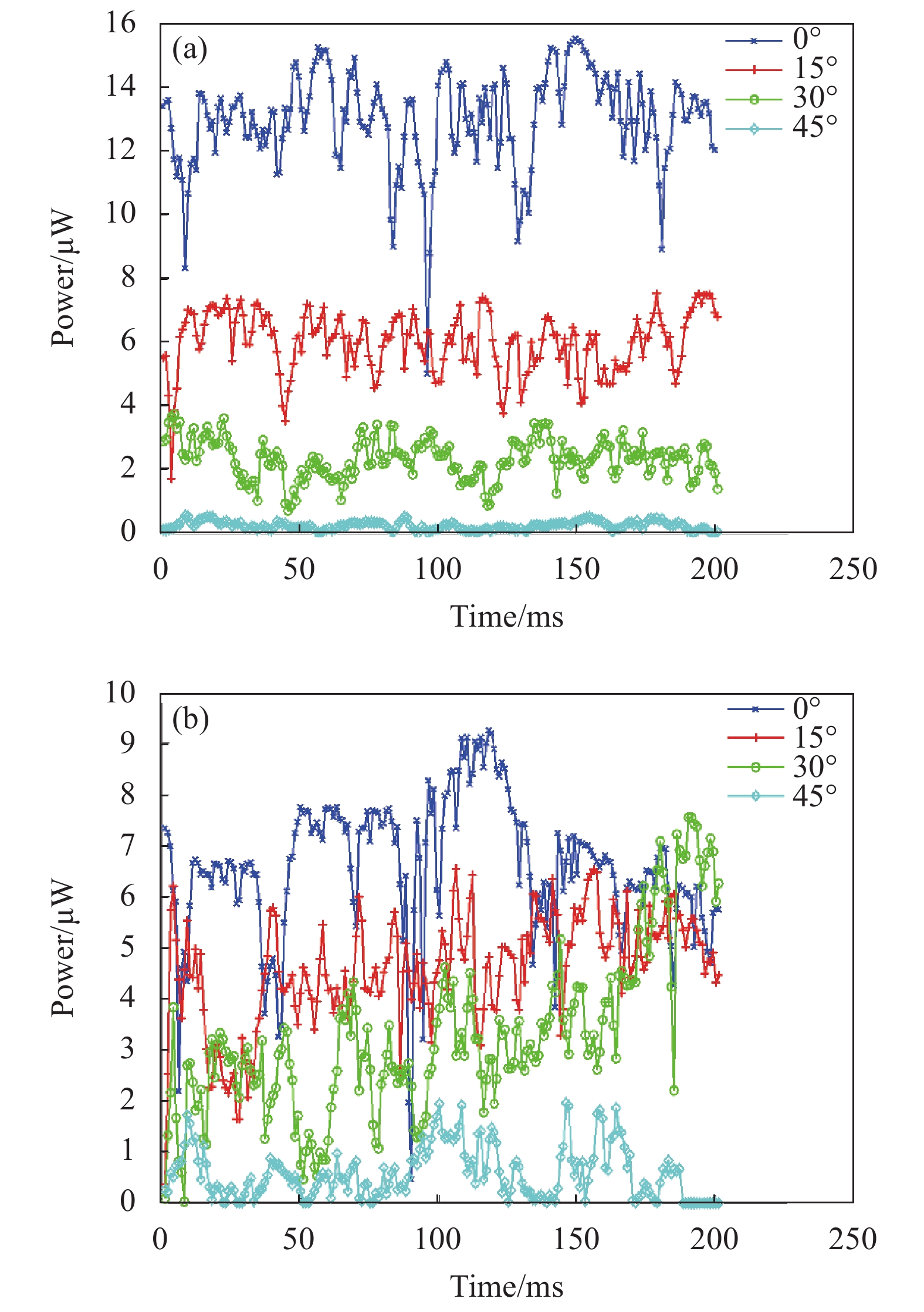
(3) 激光束垂直入射0°(垂直水面)时最大,当入射角逐渐增大,其回波功率开始下降。窄视场受入射角变化的敏感性高于宽视场。图11是窄视场探测的回波信号采集图。当入射角为0°垂直入射时,回波信号最大,达到饱和电压3.5 V,并随着水面的波动出现一段时间的聚集;当入射角增大到4°,回波幅度降低为1.5 V,同时聚焦数量大幅降低,呈现离散分布;当入射角提高到7°,回波信号被水面截止,偶尔被出现大倾斜水表面触发。采集设备显示结果见图11。

图 11 (a) 窄视场激光束入射角0°的回波动态分布; (b) 窄视场激光束入射角4°的回波动态分布;(c) 窄视场激光束入射角7°的回波动态分布
Figure 11. (a) Dynamic distribution of echoes with a narrow-field laser beam incident angle of 0°; (b) Dynamic distribution of echoes with a narrow-field laser beam incident angle of 4°; (c) Dynamic distribution of echoes with a narrow-field laser beam incident angle of 7°
宽视场探测装置在入射角分别为0°时激光回波信号饱和并稳定连续输出;当入射角增加到10°时,回波幅度不饱和,其幅度受水面波动调制;当入射角增加到15°,回波幅度继续降低,其幅度受水面波动调制。回波特征始终呈现连续性,由于水面波动存在随机性,很难利用该特征进行算法设计,采集设备显示结果见图12。

图 12 (a) 宽视场激光束入射角0°的回波动态分布; (b) 宽视场激光束入射角10°的回波动态分布;(c) 宽视场激光束入射角15°的回波动态分布
Figure 12. (a) Dynamic distribution of echoes with a wide-field laser beam incident angle of 0°; (b) Dynamic distribution of echoes with a wide-field laser beam incident angle of 10°; (c) Dynamic distribution of echoes with a wide-field laser beam incident angle of 15°
-
为验证文中低空海背景识别算法在不同交会条件下的有效性,在文中的海面背景仿真平台中开展了识别算法准确率的数字仿真统计。通过统计正确识别目标和正确识别背景的准确率(accuracy)来评估识别算法的有效性。根据准确率的定义,系统的准确率为预测正确的数量(包括正确的正类和负类)占总数的比例,准确率(accuracy)满足公式(9):
$$ \mathrm{a}\mathrm{c}\mathrm{c}\mathrm{u}\mathrm{r}\mathrm{a}\mathrm{c}\mathrm{y}=\frac{TP+TN}{TP+TN+FP+FN} $$ (9) 式中:TP为将目标正确识别为目标;TN为将海背景正确识别为海背景;FP为将海背景错误识别为目标;FN为将目标错误识别为海背景。
仿真模拟了引信在海背景中识别目标的工作过程。在遇到目标前,引信先以一定交会角与海平面交会,考核识别算法是否能抵抗海面背景的干扰。若正确识别为海背景,则判定该次抗干扰成功,该次仿真判定为TN;若误动作,将判定该次为FP;当引信遇到目标后能正确识别目标,则仿真判定为TP,若没有识别出目标,则判定该次为FN。仿真过程对目标距离海面高度选取3、4、5 m三种状态,每个高度各进行了200个交会状态的仿真,其交会状态通过蒙特卡洛法随机生成。为评估不同海况下的适应性,进行了不同海况下的仿真模拟。通过仿真将不同高度和海况的结果进行统计,得到了算法的平均准确率为96.9%,其具体结果见表2。
表 2 识别准确率仿真统计结果
Table 2. Simulation statistical results of recognition accuracy
Sea state Wind speed/
m·s−1Target height Average
accuracy3 m 4 m 5 m 2 3 96.7% 98.2% 99.1% 98% 4 10 95.1% 97.3% 98.7% 97.03% 5 15 94.3% 95.1% 97.6% 95.67% Average
accuracy95.37% 96.87% 98.47% 96.9% 从仿真过程来看,算法识别错误主要涉及两种情况。一种是在大角度等不利交会条件下,由目标有效投影截面变小导致与海面动态形体特征对比下降所致;另一种是由于高海况条件下,海面波高较大,当引信距离海面较近时,海面的回波强和局部回波离散性的下降导致了引信对海面的误动作。
-
文中基于超低空海洋环境背景下引信目标探测与识别的问题,提出了一种基于数字化阵列激光扫描成像的目标识别方法。通过动态海面和激光反射系统建模,对比分析了视场角与入射角参数对海面反射的影响。并通过针对弹目高速交会工作特点,提出了帧内判定、帧间累积的低空海背景目标识别算法。并开展了回波特征实测和仿真验证,得到以下主要结论:
(1)当激光束入射角增大时,后向反射回波能量随入射角的增加而降低;大视场角探测系统的海背景反射回波随入射角的变化连续降低,而小视场角探测系统受海面高度起伏的后向反射方向的离散性大,随入射角变化时有时无,呈现闪烁特征;
(2)采用视场细分的成像探测系统,海面回波在连续视场为离散的闪烁特征与目标回波为连续实体反射特征,两者的空间分布的特征存在差异;
(3)提出了一种阵列激光扫描成像探测系统,可实现阵列激光回波灰度和距离值的数字化,并通过直通滤波、数学形态学滤波、目标形态特征等方法能快速滤除海背景杂波,经仿真验证,该方法对不同海况下的识别准确率的平均值为96.9%。
Target recognition method of digital laser imaging fuze in ultra-low sea background
-
摘要: 激光成像技术能获得精细化的空间信息,在解决超低空海洋环境背景下的目标探测与识别时具有独特的优势。文中基于海谱波动模型和激光海面回波反射特征的模拟,仿真分析了探测系统的视场角和入射角参数对海面回波特征的影响,对比分析了宽视场和窄视场在不同海况下的激光回波特征,并对比窄视场成像探测系统对目标反射和海面反射的空间分布差异。提出了一种数字化阵列激光扫描成像探测系统,该系统通过电控阵列激光分时高速工作可实现周向360°的固态扫描探测,并通过高速AD采样获取数字化的回波幅度和距离阵列。针对弹目高速交会的工作特点,提出了帧内判定,帧间累积的低空海背景目标识别方法。该方法通过直通滤波、数学形态学滤波、目标形态特征等方法能快速滤除海背景杂波,保证弹载探测识别的实时性和可靠性要求。通过不同交会条件的仿真验证,该方法对不同海况下的识别准确率的平均值为96.9%。Abstract:
Objective In order to meet the tactical requirements of modern naval warfare, air-to-air missiles should be capable of intercepting ultra-low altitude sea-sweeping flight targets such as anti-ship missiles and cruise missiles. At present, the advanced level in the world has been able to fly at a height of 3 m above the sea. In this case, the complex sea background clutter will not only affect the detection and tracking of the missile guidance system to the target, but also enter the range of the fuze at the end of the rendezvous phase, which will seriously affect the fuze work, leading to false alarm or reduced starting ability. Therefore, improving the ability of fuze to resist ultra-low altitude sea background interference has always been a research focus to expand its battlefield adaptability. At present, conventional laser fuzes use multi-quadrant zonal wavegate compression, dual-beam detection and other technologies to suppress sea clutter, but each has certain application limitations. In this paper, a low altitude sea background target recognition method based on digital laser imaging is proposed. This method is based on the difference of imaging characteristics between the sea level and the physical target in the space distribution, and uses the fine recognition ability of laser imaging to the echo characteristics of different azimuth angles, which can improve the adaptability of proximity fuze to work reliably in the ultra-low altitude sea environment. Methods The dynamic sea surface laser echo simulation system is established to obtain the laser scattering characteristics of sea level and target. The simulation system can set the field angle parameters of the laser imaging system, and can obtain the echo signal characteristics under different intersection conditions and different sea conditions in real time. The scattering model of sea surface panel segmentation is used to calculate the laser echo distribution characteristics under different detection field angle parameters. The simulation flow chart is shown (Fig.1). Through the statistics and analysis of the distribution characteristic data of the laser scattering echo on the sea surface, a target recognition method based on the laser imaging system for low altitude sea background is designed and verified by simulation. Results and Discussions In terms of target characteristic simulation, for the imaging detection system that uses spatial narrow field of view subdivision, due to the undulation of the sea surface, the sea surface echo presents discrete flicker feature in the spatial distribution (Fig.5), which is significantly different from the imaging feature of continuous solid targets (Fig.6) in the spatial distribution. In terms of target recognition method design, a circumferential 360° solid-state array laser high-speed scanning detection system is proposed, and full digital echo signal processing is realized through high-speed AD sampling. According to the characteristics of high-speed rendezvous between missile and target, a method of low altitude sea background target recognition based on intra-frame judgment and inter-frame accumulation is proposed. This method can quickly filter out the sea background clutter by means of straight-through filtering, mathematical morphology filtering, target morphology features and other methods to ensure the real-time and reliability requirements of missile-borne detection and recognition. The average recognition accuracy of this method under different sea conditions is 96.9% (Tab.2) through simulation verification of different intersection conditions. Conclusions In this paper, a target recognition method based on digital array laser scanning imaging is proposed. This method can realize circumferential 360° solid state scanning detection through the time-sharing and high-speed operation of the electronically controlled array laser, and digitize the echo imaging features through high-speed AD sampling. It has the characteristics of fast recognition speed and high degree of digitalization, and can meet the real-time requirements of high-speed target recognition. The digital modeling of sea surface and laser detection has been carried out, and the optical reflection characteristics of sea clutter have been simulated and analyzed. Based on the target characteristics, a low-altitude sea background target recognition method of intra-frame judgment and inter-frame accumulation has been designed. Through simulation and test verification, the average recognition accuracy of this method under different sea conditions is 96.9% (Tab.2). The relevant technologies in this paper can provide methods and ideas for laser fuze anti-low altitude sea environment interference technology. -
Key words:
- laser fuze /
- laser imaging /
- anti-interference /
- point cloud feature recognition
-
图 2 (a)风速3 m/s,风向0°的动态海面几何模型;(b)风速10 m/s,风向45°的动态海面几何模型
Figure 2. (a) Dynamic sea surface geometric model with wind speed of 3 m/s and wind direction of 0°; (b) Dynamic sea surface geometric model with wind speed 10 m/s and wind direction 45°
图 3 (a) 45°视场角探测的海面回波仿真场景;(b) 2°视场角探测的海面回波仿真场景
Figure 3. (a) Sea surface echo simulation scene for 45° field of view detection;(b) Sea surface echo simulation scene for 2° field of view detection
图 4 (a) 低海况下宽视场探测回波随入射角的变化曲线;(b) 高海况下宽视场探测回波随入射角的变化曲线
Figure 4. (a) Variation curves of wide-field detection echo with incident angle in low sea state;(b) Variation curves of wide-field detection echo with incident angle in high sea state
图 5 (a) 低海况下窄视场探测回波随入射角的变化曲线;(b) 高海况下窄视场探测回波随入射角的变化曲线
Figure 5. (a) Variation curves of narrow-field detection echo with incident angle in low sea state;(b) Variation curves of narrow-field detection echo with incident angle in high sea state
图 6 (a) 目标数字模型;(b) 不同俯仰角交会情况下目标回波的功率曲线
Figure 6. (a) Target digital model;(b) Target laser echo power curves with different pitch angles
图 9 (a)目标在海背景中的原始点云分布;(b)直通滤波后的点云分布;(c)腐蚀运算后的点云分布;(d)数学形态学滤波后的点云分布
Figure 9. (a) Original point cloud distribution of the target in the sea background;(b) Point cloud distribution after pass-through filtering;(c) Point cloud distribution after erosion operation;(d) Point cloud distribution after mathematical morphology filtering
图 10 (a)人工模拟海面的激光回波特性试验布置原理; (b)人工模拟海面场景
Figure 10. (a) Layout principle of laser echo characteristic test for artificially simulated sea surface;(b) Artificial simulation of the sea scene
图 11 (a) 窄视场激光束入射角0°的回波动态分布; (b) 窄视场激光束入射角4°的回波动态分布;(c) 窄视场激光束入射角7°的回波动态分布
Figure 11. (a) Dynamic distribution of echoes with a narrow-field laser beam incident angle of 0°; (b) Dynamic distribution of echoes with a narrow-field laser beam incident angle of 4°; (c) Dynamic distribution of echoes with a narrow-field laser beam incident angle of 7°
图 12 (a) 宽视场激光束入射角0°的回波动态分布; (b) 宽视场激光束入射角10°的回波动态分布;(c) 宽视场激光束入射角15°的回波动态分布
Figure 12. (a) Dynamic distribution of echoes with a wide-field laser beam incident angle of 0°; (b) Dynamic distribution of echoes with a wide-field laser beam incident angle of 10°; (c) Dynamic distribution of echoes with a wide-field laser beam incident angle of 15°
表 1 海况与风力、浪高、风速对应关系表
Table 1. Correspondence between sea conditions and wind, wave height and wind speed
Sea state Wind Wind speed/m·s−1 Wave height/m Significant Extremum 0 Level 0 0.0-0.2 − − Level 1 0.3-1.5 0.1 0.1 1 Level 2 1.6-3.3 0.2 0.3 2 Level 3 3.4-5.4 0.6 1 3 Level 4 5.5-7.9 1 1.5 4 Level 5 8-10.7 2 2.5 5 Level 5 10.8-13.8 3 4 Level 5 13.9-17.1 4 5.5  下载: 导出CSV
表 2 识别准确率仿真统计结果
Table 2. Simulation statistical results of recognition accuracy
Sea state Wind speed/
m·s−1Target height Average
accuracy3 m 4 m 5 m 2 3 96.7% 98.2% 99.1% 98% 4 10 95.1% 97.3% 98.7% 97.03% 5 15 94.3% 95.1% 97.6% 95.67% Average
accuracy95.37% 96.87% 98.47% 96.9%
下载: 导出CSV
-
[1] 崔占忠, 宋世和, 徐立新. 近炸引信原理[M]. 第3版. 北京: 北京理工大学出版社, 2005. Cui Zhanzhong, Song Shihe, Xu Lixin. Principle of Proximity Fuze[M]. 3rd ed. Beijing: Beijing Institute of Technology Press, 2005. (in Chinese) [2] Yuan Zheng. The Summarization for laser fuze [J]. Aero Weaponry, 1998(3): 31-38. (in Chinese) doi: 10.19297/j.cnki.41-1228/tj.1998.03.011 [3] Liu Yuelong, Zhang Yan. Summarization of low altitude fuze technology [J]. Guidance & Fuze, 2010, 31(4): 1-6. (in Chinese) doi: 10.3969/j.issn.1671-0576.2010.04.001 [4] Fan Huitao, Zhang Pengpeng. The challenges for air-to-air missile [J]. Aero Weaponry, 2017(2): 3-7. (in Chinese) doi: 10.19297/j.cnki.41-1228/tj.2017.02.001 [5] Fan Huitao, Cui Hao, Tian Guang. A review on the 70-year development of air-to-air missiles [J]. Aero Weaponry, 2016(2): 3-12. (in Chinese) doi: 10.19297/j.cnki.41-1228/tj.2016.01.001 [6] Ma Jingjun, Ma Weijun, Zhao Mingbo, et al. Low altitude/very low altitude penetration and radar countermeasures [J]. National Defense Science & Technology, 2011(3): 26-35. (in Chinese) [7] Cai Kerong, Kong Weidong, Jia Dao. The laser fuze anti-sea clutter technique based on respective gate compression method [J]. Digital Technology and Application, 2016(3): 85-87. (in Chinese) doi: 10.19695/j.cnki.cn12-1369.2016.03.055 [8] Lu Ming, Su Yide, Kong Dehao. The study on laser fuze with dual beam detection technology that anti-jamming sea clutter [J]. Journal of Ordnance Equipment Engineering, 2017, 38(12): 247-252. (in Chinese) doi: 10.11809/scbgxb2017.12.054 [9] Liu Bohu, Song Chengtian, Duan Yabo. Design and simulation of a panoramic laser imaging fuze [J]. Infrared and Laser Engineering, 2018, 47(4): 0406003. (in Chinese) doi: 10.3788/IRLA201847.0406003 [10] Sun Zhihu, Deng Jiahao, Yan Xiaowei. Progress and current state of the development of laser imaging detection system and its keytechniques [J]. Science & Technology, 2010, 28(4): 74-79. (in Chinese) [11] Wang Xiaoju, Ma Heng, Zhang Shunfa. Laser gray imaging fuze technology for air-to-air missile [J]. Infrared and Laser Engineering, 2018, 47(3): 0303002. (in Chinese) doi: 10.3788/IRLA201847.0303002 [12] Ji Yunfei, Geng Lin, Feng Guoxu, et al. New development of laser imaging technology [J]. Laser & Infrared, 2015, 45(12): 1413-1417. (in Chinese) doi: 10.3969/j.issn.1001-5078.2015.12.002 [13] Xu Zhengping, Shen Honghai, Xu Yongshen. Review of the development of laser active imaging system with direct ranging [J]. Chinese Optics, 2015, 8(1): 28-38. (in Chinese) doi: 10.3788/co.20150801.0028 [14] Gary Buzzard. Development in laser target detection device technology[C]//3rd Annual Missiles & Rockets Symposium and Exhibition, Panama City, Florida, Apr 17-19, 2002. [15] Pierson W J, Moscowitz L. A proposed spectral form for fully developed wind seas based on the similarity theory of S. A. kitaigorodsrii [J]. J Geophys Res, 1964, 69(24): 5181-5190. doi: 10.1029/JZ069i024p05181 [16] Elfouhaily T, Chapron B, Katsaros K, et al. A unified directional spectrum for longand short wind-drived waves [J]. J Geophys Res, 1997, 102(C7): 15781-15796. doi: 10.1029/97JC00467 [17] 俞聿修. 随机波浪及其工程应用[M]. 大连: 大连理工大学出版社, 1992. Yu Yuxiu. Random Wave and Engineering Application[M]. Dalian: Dalian University of Technology Press, 1992. (in Chinese) [18] Yang Huaiping, Sun Jiaguang. Wave simulation based on ocean wave spectrums [J]. Journal of System Simulation, 2002, 14(9): 1175-1178. (in Chinese) doi: 10.3969/j.issn.1004-731X.2002.09.017 [19] Fournier A, Reeves W T. A simple model of ocean waves[C]//Proceedings of the 13th Annual Conferenceon Computer Graphics and Interactive Techniques, 1986: 75-84. [20] Li Ke, Wang Jiang'an, Pan Chen. Study about analytical cha-racter of laser diffusion from sea surface [J]. Laser & Infrared, 2011, 41(5): 525-530. (in Chinese) doi: 10.3969/j.issn.1001-5078.2011.05.009 [21] Lu Qi, Lin Tingting, Li Chengpeng, et al. Improved registration algorithm for spatial non-cooperative target point cloud clustering [J]. Infrared and Laser Engineering, 2021, 50(9): 20200431. (in Chinese) doi: 10.3788/IRLA20200431 [22] Jin Shenghong, Yang Honghai, Wang Lianyu. Research on slope filtering of point cloud data based on gridding LIDAR [J]. Geomatics & Spatial Information Technology, 2013, 36(6): 154-156. -

 点击查看大图
计量
- 文章访问数: 178
- HTML全文浏览量: 40
- PDF下载量: 30
- 被引次数: 0


