


-
激光测高是主动式遥感技术的一种。激光测高卫星发射一束短脉冲激光,经过地面探测目标的后向散射后,使用卫星装置的探测器接收这一回波脉冲,通过获取发射脉冲和接收脉冲之间的时间差,来计算出地面探测目标与卫星之间的距离[1]。全波形激光雷达技术通过数字化采样获取了回波脉冲的完整波形,不仅可以获取被探测目标的距离,还可以提取出激光足印范围内被测目标的垂直结构信息与地形特征,如地形粗糙度、森林冠层垂直结构、地物分布等 [2-6]。全波形回波波形可以认为是在一个激光足印范围内,不同高度的多个被测目标面散射后产生的回波脉冲的叠加。因此,可以通过波形分解技术获取单个被测地物目标的回波波形,进而由分析其高程与其他垂直结构信息。所以全波形数据的处理至关重要。国内外学者都对此进行了一定的研究,Hofton等人对原始激光回波信号进行高斯分解,并且对分解后的波形进行进行拟合[7];Zhou T,Popescu S C等人提出了一种非线性反卷积的波形处理方式,对较小地物的回波强度进行了放大,从而可以分解出更多的地物,但是此方法不具有通用性,且对预处理的方法要求较高[8];由于地物组成的复杂性,可能导致回波信号不完全符合高斯分布,马跃等人提出了一种自适应高斯滤波的方法对全波形数据进行平滑降噪,解决了固定宽度高斯滤波方法造成的信号位置偏移问题,并对南极冰盖高程变化进行计算[9];李洪鹏等人提出了改进的LM回波波形分解方法,并且采用可变阈值的经验模态分解滤波法(EMD-soft)对原始波形进行滤波和噪声水平评估,采用一套应对多种波形组成的初始参数估计方法,获取后续拟合所需的初始参数[10];李奇和马洪超等人提出了一种改进的EM脉冲检测算法来计算激光回波波形高斯分量的位置和脉宽[11];崔成玲针对传统的奇偶拐点高斯分解法提取高斯分量峰值点不准确,效率低的问题,提出了一种自动识别波峰的分解方法,但是此方法对于波形的隐藏峰提取能力较弱[12]。
综上所述,目前的数据处理方法都对于待处理的波形数据和初始参数的准确性具有非常高的要求,如果输入的初始参数与期望值差距太大,会导致拟合收敛到局部最小值,而不是所需的全局最小值,甚至导致拟合发散。因此,文中提出了一种基于遗传算法的全波形数据处理方法,解决分解过程过于依赖初始参数的问题,进而提高拟合精度。
-
(1)波形背景噪声估计
波形信号中包含了因传感器本身等因素影响造成的系统误差,即背景噪声。因此需要消除这部分噪声对激光测高的影响。其计算公式如下:
式中:
$ {E}_{100} $ 为通过经验公式估算的背景噪声阈值;$ {m}_{100} $ 为电压值转换之后前100帧数据的平均值;$ {s}_{100} $ 为前100帧波形采样点数据的均方差;$ {V}_{i} $ 为第i帧数据的电压值;${\bar V} $ 为前100帧数据电压的平均值。(2)波形滤波
星载激光测高仪发射脉冲的能量分布符合标准的高斯函数,通常将标准高斯函数的一阶导函数作为高斯滤波核函数,也称为高斯滤波器,如公式(4)所示:
式中:
$ \sigma $ 和$ t $ 分别为标准高斯分布的脉宽和高斯峰值位置。平滑之后的波形可以用公式(5)表示:式中:
$ f\left(t\right) $ 为剔除背景噪声后的有效信号;$ \otimes $ 为卷积计算符号。 -
激光波形信号通常是多个地物目标反射形成的,通过对激光回波信号进行分解提取单个地物的垂直信息,为了得到准确的波形特征参数,通常需要对分解后的结果进行拟合[8-12]。对于高分七号激光波形来说,拟合目标函数可以表示为公式(6)。受限于激光测高仪的硬件系统,通常认为回波波形中最多可以提取6个地物目标的高度信息[10]。
如图1所示,高斯分解算法对于平坦地形下的简单回波,可以快速准确地提取高斯参数,但是对于图2所示复杂地形下的混叠波形,高斯分量提取能力差。由于该波形为多个地物目标回波共同叠加的效果,对于隐藏的高斯分量不能有效地识别。

Figure 1. Gaussian decomposition of a single figure
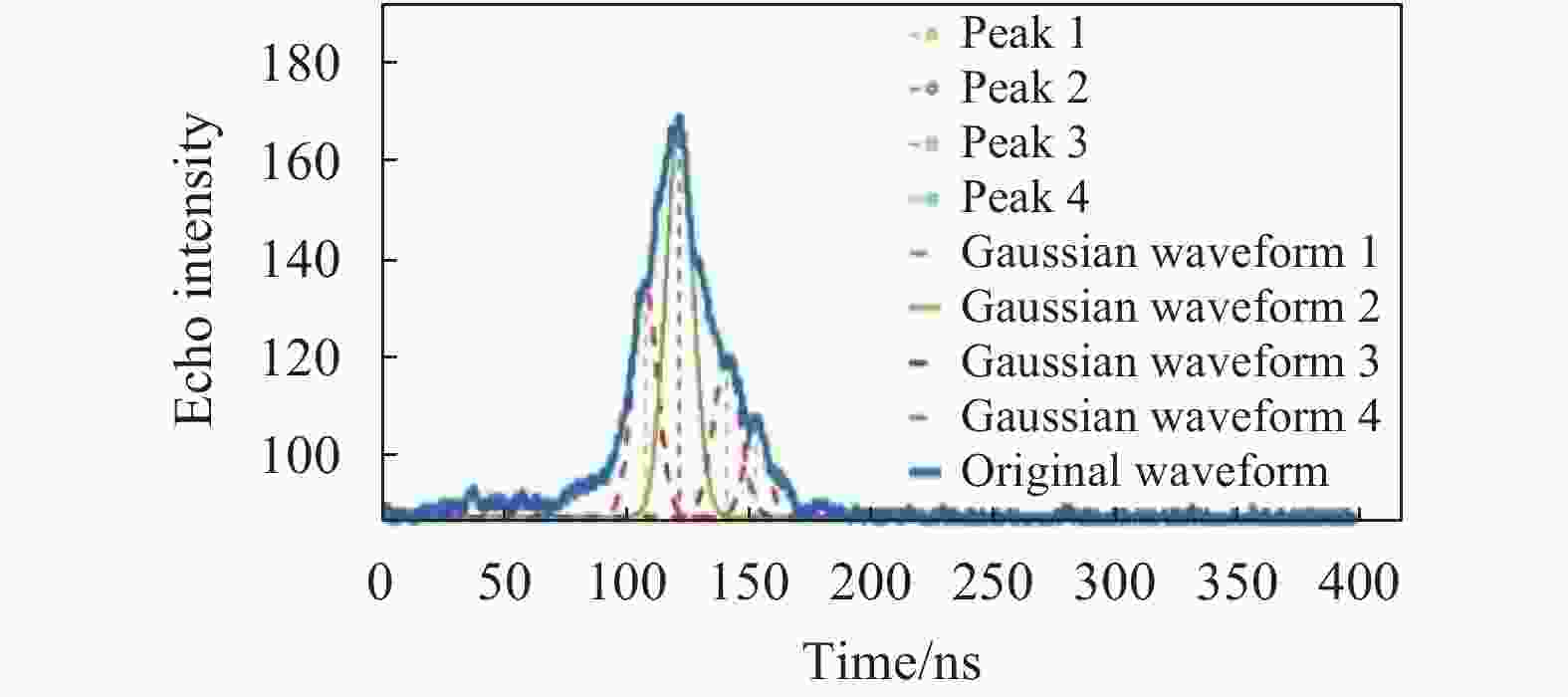
Figure 2. Laser waveform in complex terrain
-
全波形星载激光雷达的波形数据中包含地物目标的垂直结构信息,通过波形数据处理可以将这些信息提取出来用于测绘、林业等生产与科研领域[13]。目前常用的全波形数据分解方法需要提供非常准确的波形初始参数,否则会导致提取的高程信息不准确。针对这一问题,文中提出了一种基于遗传算法的全波形分解方法,改进后的处理算法无需提供精确的初始参数,具有全局寻优特点[14]。基于遗传算法波形分解的基本运算过程如下:
(1)波形数据预处理,消除因外界环境和仪器系统等引起的噪声;
(2)波形分解:根据两个拐点与一个极大值点确定一个高斯分量,按照一定的原则等进行高斯分量合并,得到高斯分量的初始参数;
(3)参数编码:设置拟合迭代次数的最大阈值和拟合收敛的标准(一般将回波3倍标准差作为拟合收敛的标准,文中也采取此原则进行拟合收敛判断)。使用实数编码在拐点法波形分解得到的初始参数一定范围内随机生成N个个体作为初始群体G(0)。此次实验将N设置为20;
(4)计算适应度:以拟合的残差和为标准,对进化后的所有个体的适应度进行计算;
(5)选择运算:根据步骤(4)中计算的适应度,选择适应度大的个体进入下一代;
(6)交叉运算:交叉运算是整个遗传算法的关键。此次实验按照如下公式进行参数个体交叉运算。
式中:
$ {x}_{A}^{t+1} $ 和$ {x}_{B}^{t+1} $ 是交叉运算之后的个体;$ {x}_{A}^{t} $ 和$ {x}_{B}^{t} $ 是随机选择的交叉运算之前的两个个体;$ t $ 是遗传运算的代数;$ \alpha $ 是交叉运算的常数,取值范围为(0,1);(7)变异运算:变异运算的实质就是对高斯分量的初始参数按一定的规则进行随机变化,从而得到新的个体。变异运算的公式如下:
式中:
$ {x}_{A}^{t+1} $ 为变异运;$ {x}_{A}^{t} $ 为变异之前的个体;$ k $ 是一个变异常数,取值范围为(0,1);${x}_{{\rm{max}}}$ 和${x}_{{\rm{min}}}$ 分别为个体中参数的最大值和最小值;$ r $ 是一个随机数。(8)遗传终止判断:当迭代次数达到设定的阈值或拟合收敛,输出具有最大适应度的个体。
-
(1)波形拟合的残差和为:
式中:N为波形采样点数;
$ {f}_{i} $ 为拟合后第i个采样波形的电压值;$ {y}_{i} $ 为预处理后波形第i个采用波形的电压值;$ \varepsilon $ 为波形拟合的残差和。(2)森林冠层高度
线性体制激光雷达回波波形的有效信号起始点是激光足印内树冠顶端的位置,有效信号结束位置是地面的位置[15-16]。根据下式进行森林最大冠层高度的计算:
式中:H为森林最大冠层高度;Groundpeak为地面回波峰值位置;SigBeg是回波波形有效信号的起始位置,单位均为ns;BinSize=15 cm。
(3)基于波形反演的最大树高与真实树高的相关系数为:
式中:Hwave为基于波形反演的最大树高;H为真实树高;Cov(Hwave, H)为Hwave与H的协方差;Var[Hwave]和Var[H]分别为Hwave与H的方差。
(4)该区域内所有基于波形数据处理反演的最大树高与真实树高差值的平均值为:
式中:
$ \Delta H $ 为基于波形反演最大树高与真实树高的差值;$ N $ 为波形采样点数。(5)基于波形反演的最大树高的中误差为:
式中:
$ \Delta H $ 为基于波形反演最大树高与真实树高的差值;$ N $ 为波形采样点数;$ RMSE $ 为基于波形反演的最大树高的中误差。 -
(1)高分七号波形数据
高分七号卫星是我国首个下传波形数据的激光测高卫星,其平均轨道高度约为505 km。激光脉冲在地面形成直径小于30 m的类圆激光足印,并以高于1 GHz的采样频率获取全波形数据。高分七号激光测高仪的基本参数如表1所示。
Parameters Value Laser beam 2 Pulse wavelength/nm 1064 Pulse energy/mJ 100-180 (adjustable) Pulse width/ns 4-8 Repetition rate/Hz 3/6 (adjustable) Digital interval/ns 0.5 Ranging range/km 450-550 Ranging accuracy/m ≤0.3 Table 1. Basic parameters of the GF-7 laser altimeter
(2) DEM数据
ALOS是日本于2006年1月24日发射的对地观测卫星,文中利用ALOS的12.5 m DEM数据计算地表坡度。
(3) ICESat-2数据
由于目前缺少试验区的实测数据,文中采用ICESat-2的ATL08数据作为验证数据,只分析两种数据计算树高之间的相关性。ICESat-2的ATL08产品包含沿轨道方向的地形和树冠高度,以及由森林地区的其他描述性参数。ATL08产品在计算森林冠层高度时也消除了地形因素的影响,测高精度为米级。
-
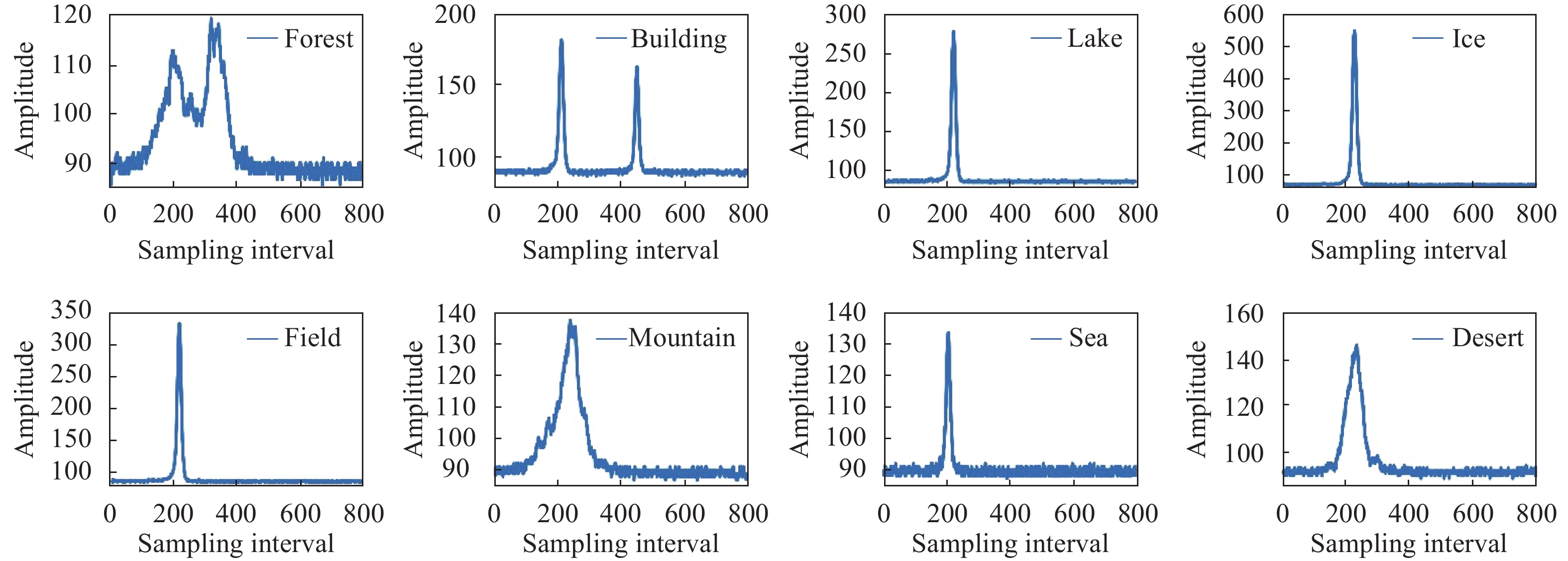
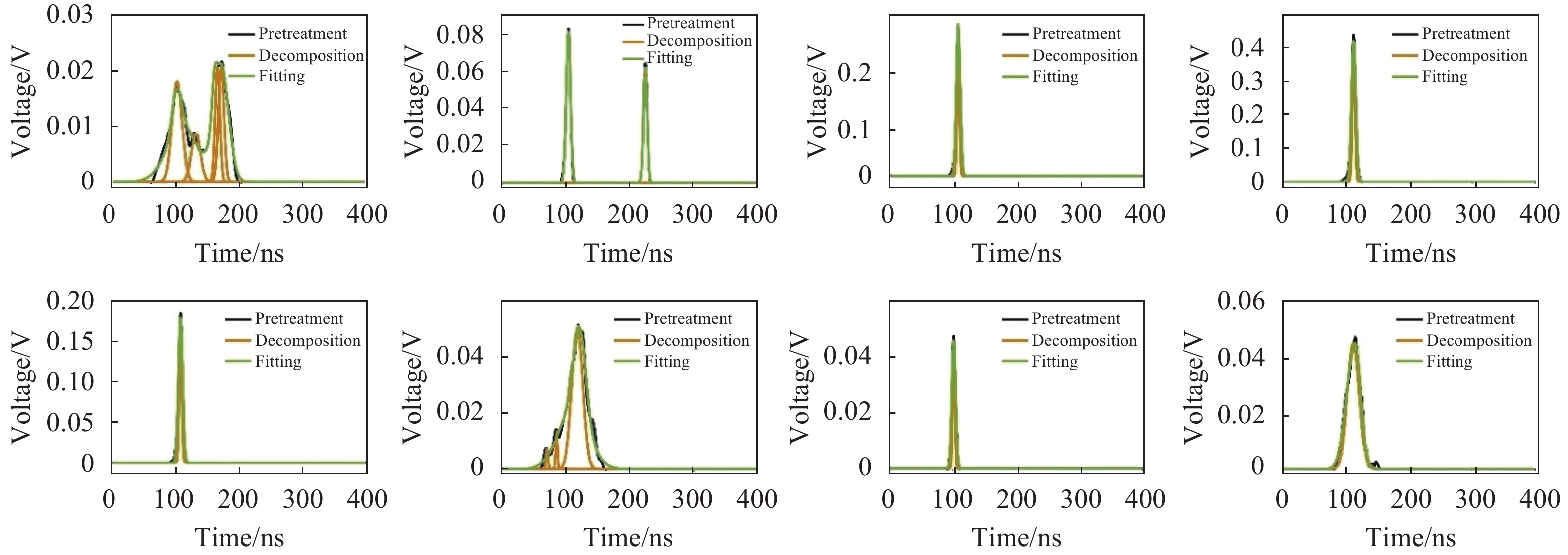
为了验证文中改进方法的普适性和准确性,此次实验选取8个典型地物的波形进行波形分解,并分析其分解的精度。高分七号波形原始数据及其处理过程分别如图3和图4所示。

Figure 3. Original waveform
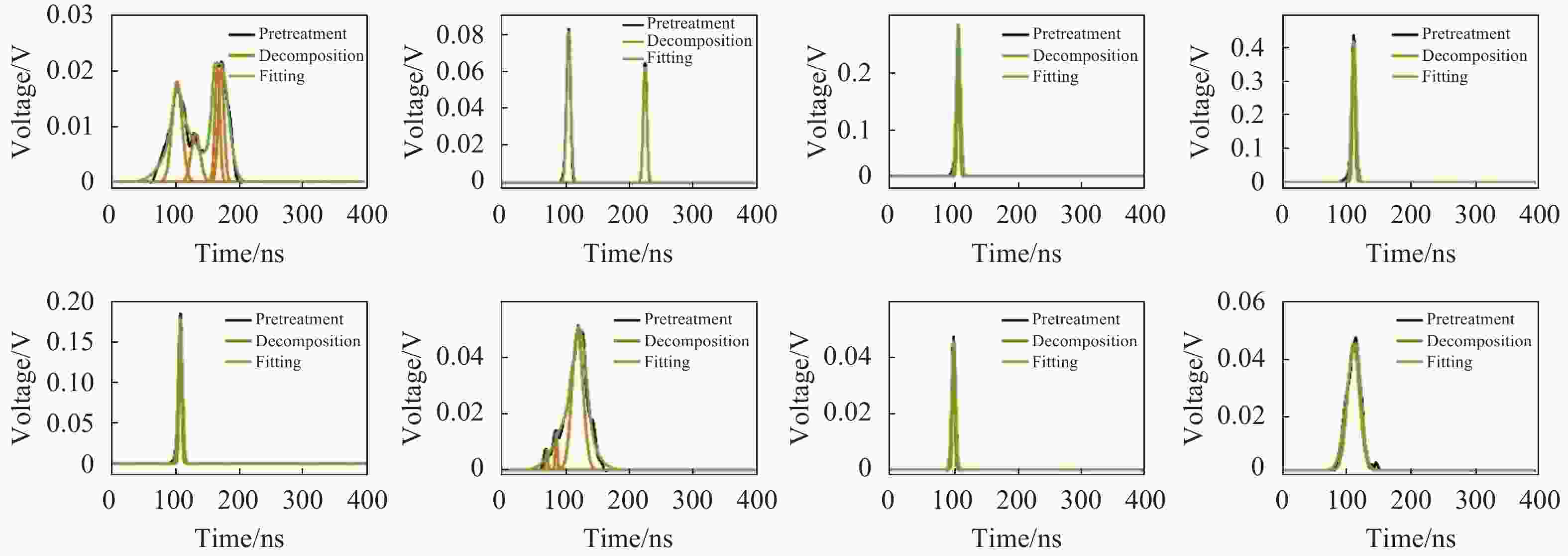
Figure 4. Fitted waveform
对传统方法和改进后数据处理方法的处理效果进行统计分析,统计其提取的波形分量的个数,用于分析其探测波形中隐藏波峰的能力,统计其拟合后残差的平方和,用于分析两种方法的拟合精度;统计两种方法的相关系数的平方,用于分析处理后的波形与原始波形的相关性。统计结果如表2所示。由图4和表2可以看出,对于湖、海洋、耕地、冰盖、沙漠等单一波峰的回波波形,两种方法得到的结果基本一致,均可以达到不错的分解效果,但是对于林地、山地等复杂地区,改进后的方法明显优于传统波形分解方法的效果。尤其是对于林地地区,传统方法受波形分解时初始参数计算的准确度影响容易拟合发散,而改进后的算法对初始参数的精确度要求低,可以避免这个问题。通过上述分析可以得出文中算法与传统的波形分解方法相比,拟合精度提高,而且可以对混叠峰进行分离。
Feature type Traditional method Improved waveform data processing method Number RSS R2 Number RSS R2 Forest 2 Divergence 0 4 0.000 17 0.993 Mountain 1 0.005 674 0.931 3 0.000 16 0.997 Desert 1 0.000 679 0.990 5 1 0.000 169 9 0.997 Duilding 2 0.000 835 0.999 2 0.000 07 0.999 Lake 1 0.000 373 9 0.998 1 0.000 04 0.999 Sea 1 0.000 16 0.99 1 0.000 04 0.999 Field 1 0.001 18 0.997 1 0.000 04 0.999 Ice 1 0.000 26 0.99 1 0.000 04 0.999 Table 2. Statistical table of waveform decomposition test results
为了进一步分析文中算法的有效性,根据现有的高分七号卫星数据,挑选(115E,24N)~(117E,30N)范围作为研究区域,考虑地形坡度对树高反演精度的影响,文中采用激光发射波形数据的3倍标准差对波形数据进行校正,地面回波波形的半波宽等于该激光点发射脉冲的3倍标准差,受地形坡度影响导致森林冠层回波波形和地面回波波形都发生一定程度的展宽[15]。波形展宽应该是地面回波与发射脉冲的3倍标准差之差,消除波形展宽后重新计算波形起始点的位置进行坡度校正,但是该方法也有一定的局限性,对于坡度较大的地区校正效果较差。所以文中只使用地形坡度小于15°的高分七号波形数据。在此试验区内高分七号数据有一轨数据,第446轨数据,研究区内拥有原始激光点数量526个,其中符合文中实验要求的林地类激光点数量为43个。研究区内激光点及地形坡度如图5所示。然后根据公式(11)中的森林冠层高度提取方法,使用传统方法和改进后方法对研究区内的森林冠层高度进行反演。并与ICESat-2的数据进行对比统计,结果如表3所示。
Evaluating indicator ME/m RMSE/m COV Traditional method 0.618 3.160 9 0.71 Improved waveform data processing method 0.534 1.160 9 0.87 Table 3. Indexs comparison of accuracy evalution of the height extraction used by the traditional method and the improved method
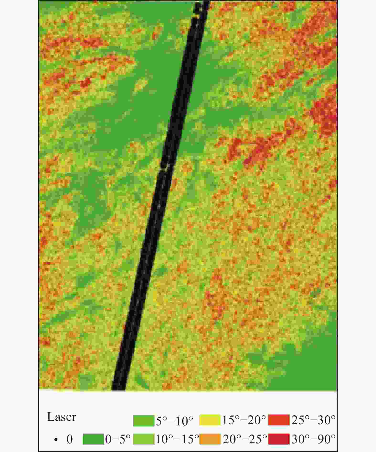
Figure 5. Data and gradient distribution map of GF-7 in the study area
图6表明了ICESat-2的冠层高度与基于高分七号波形计算的冠层高度之间的相关性。可以看出,两者之间有很好的相关性,经过计算得出其相关系数为0.87,而传统方法的相关系数为0.71,说明文中基于波形参数计算的冠层高度与ICESat-2测量的地面冠层高度基本一致,然后分析其误差中误差,对比发现,文中算法的中误差为1.1609 m,而传统方法的中误差要大于3 m,所以说明文中的方法有很高的可靠性,可以用于大区域森林冠层高度估算的研究和应用。考虑高分七号还在在轨测试阶段,激光载荷只进行了粗检校,平面定位精度存在5 m左右的误差。在外业检校之后获得更加准确的平面位置信息,基于波形参数估测森林冠层高度的精度有望进一步提高。
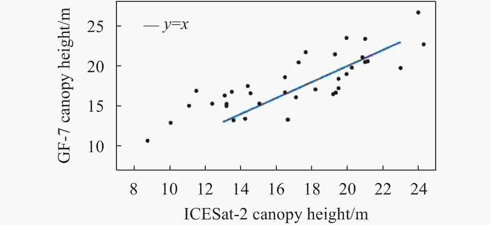
Figure 6. Data and gradient distribution map of GF-7 in the study area
-
文中提出了一种基于遗传算法的激光雷达数据处理方法,该算法能够实现全波形体制激光雷达回波波形信号的波形数据处理,而且可以解决传统方法进行波形拟合时过于依赖初始参数准确性的问题。不仅可以处理平地、海洋等简单地物的回波信号,还可以很好地处理森林等回波波形较为复杂的地区的回波信号,从中提取地物垂直结构信息,进而用于生产和应用。利用概率性传递规则代替确定性规则,具有全局寻优特点。试验证明文中基于遗传算法改进后的波形处理算法提高了地物的测高精度,拟合后波形与分解前波形的相关系数大于99%。并以我国东南方地区作为研究区,利用高分七号波形数据实现了森林地区最大冠层高度的估算,为了降低坡度对冠层高度估算的影响,文中选用坡度小于15°的区域,使用发射脉冲的3倍标准差重新定位信号起始位置对地形坡度进行校正,并用ICESat-2的ATL08产品中的冠层高度对其进行精度评价。研究发现,基于遗传算法的波形分解算法对高分七号波形数据进行处理后能较为准确地估算森林冠层高度信息。
Full waveform decomposition of spaceborne laser based on genetic algorithm
doi: 10.3788/IRLA20200245
- Received Date: 2020-06-14
- Rev Recd Date: 2020-10-18
- Publish Date: 2020-11-25
-
Key words:
- GF-7 /
- genetic algorithm /
- waveform decomposition /
- tree height measurement
Abstract: The echo of the all waveform lidar contains the vertical structure information of the ground object. The traditional all waveform data processing methods rely too much on the initial parameters when extracting these information, resulting in the low availability and accuracy of the data in the terrain complex area. To solve this problem, a waveform decomposition method based on genetic algorithm was proposed. The improved algorithm did not need to provide accurate initial parameters, and used probabilistic transfer rules instead of deterministic rules, which had the characteristics of global optimization. The experiment was carried out with the full waveform data of GF-7 satellite laser. The results show that the correlation coefficient between the echo waveform fitted by the improved waveform processing method and the preprocessed waveform is more than 99%. The inversion of the maximum tree height in the forest area was compared with the forest canopy height parameter in the ATL08 data of ICESat-2. The correlation coefficient is 0.85 and the mean square error is 1.1 m, which shows that the method can extract the feature information of complex waveform more accurately.


 DownLoad: